



RismadarVoice Reporters
September 29, 2026
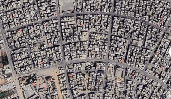
Updated satellite imagery has revealed extensive destruction across the Gaza Strip nearly three years after the war between Israel and Hamas began, with residential neighbourhoods, farmland and critical infrastructure severely damaged.
Images covering areas from Rafah in the south to North Gaza show large sections of densely populated communities reduced to rubble, while displacement camps have expanded across previously sparsely populated areas.
The United Nations Satellite Centre, UNOSAT, has documented widespread structural damage across Gaza, with assessments showing destruction continuing even after the ceasefire announced last year.

In Rafah, satellite imagery shows extensive destruction in Tal as-Sultan, where large sections of the once densely populated neighbourhood have been cleared of buildings.
Rafah had become a major refuge for Palestinians displaced from other parts of Gaza before Israeli military operations in May 2024 forced about one million people to leave the area, according to humanitarian agencies.
Many displaced residents moved towards Khan Younis, Deir el-Balah and Al-Mawasi, with some having already been displaced several times.
Al-Mawasi, a coastal area previously dominated by sand and farmland, became a major destination for displaced Palestinians after Israel designated it a humanitarian zone. Satellite imagery now shows large concentrations of tents and temporary shelters across the area.
Khan Younis has also suffered extensive structural and agricultural damage. An October 2025 UNOSAT assessment recorded 51,885 damaged structures in the governorate, the highest number in Gaza at the time.
The governorate, previously one of Gaza’s major agricultural centres, also recorded extensive damage to cropland.
Gaza City and surrounding areas have similarly experienced widespread destruction, including damage to residential buildings and economic infrastructure.
Gaza’s port, previously central to the territory’s fishing industry, has been severely damaged, while most fishing boats have been destroyed, according to the UN Food and Agriculture Organisation.
Northern Gaza has suffered extensive damage to residential areas and farmland. The UN Office for the Coordination of Humanitarian Affairs reported that 94 per cent of cropland in North Gaza had been damaged by July 2025.
Beit Lahiya and Jabalia are among communities heavily affected by repeated military operations and displacement, with satellite imagery showing large sections of residential areas destroyed.

The war began after Hamas and other Palestinian armed groups attacked Israel on October 7, 2023, killing about 1,200 people and taking more than 250 hostages, according to Israeli authorities.
Israel subsequently launched a large-scale military campaign in Gaza.
Tens of thousands of Palestinians have since been killed and many more injured, while much of Gaza’s population has experienced displacement and severe disruption to access to food, healthcare, shelter and other essential services.
The satellite imagery highlights the physical transformation of Gaza after nearly three years of conflict, with widespread damage extending across homes, agricultural land, religious sites and economic infrastructure.